 Mainamati
an isolated ridge of low hills in the eastern margins of deltaic
Bangladesh, about 8 km to the west of Comilla town is a very familiar name
in our cultural heritage, where archaeological excavations have revealed
very significant materials. A landmark of our ancient history, it
represents a small mass of quasi-lateritic old alluvium. The ridge, set in
the vast expanse of the fertile lower Meghna basin, extends for about 17
km north-south from Mainamati village on the Gumti River to Chandi Mura
near the Lalmai railway station. In its widest parts, the ridge is about
4.5 km across and its highest peaks attain a height of about 45 metres.
These highlands were once thickly wooded with an abundance of wild life,
but modern developments have rudely disturbed its serene and idyllic
setting. With an ever-expanding Cantonment at Mainamati, in the northern
half of the ridge, and a fast growing township at Kotbari in about its
centre, the fairy-tale beauty of the place is already a thing of the past.
Mainamati
an isolated ridge of low hills in the eastern margins of deltaic
Bangladesh, about 8 km to the west of Comilla town is a very familiar name
in our cultural heritage, where archaeological excavations have revealed
very significant materials. A landmark of our ancient history, it
represents a small mass of quasi-lateritic old alluvium. The ridge, set in
the vast expanse of the fertile lower Meghna basin, extends for about 17
km north-south from Mainamati village on the Gumti River to Chandi Mura
near the Lalmai railway station. In its widest parts, the ridge is about
4.5 km across and its highest peaks attain a height of about 45 metres.
These highlands were once thickly wooded with an abundance of wild life,
but modern developments have rudely disturbed its serene and idyllic
setting. With an ever-expanding Cantonment at Mainamati, in the northern
half of the ridge, and a fast growing township at Kotbari in about its
centre, the fairy-tale beauty of the place is already a thing of the past.
The twin names - Lalmai- Mainamati - of the place have significant link with the past: Lalmai or the southern part is identical with Lalambi-vana of the Chandra epigraphs, while the northern part recalls the name of the legendary Chandra queen 'Maynamati', mentioned in local ballads and folk-songs. The archaeological finds have now established beyond any doubt that the cultural and political centre of ancient Vanga-Samatata (southeast Bengal) was located here. The glory and magnitude of that remarkable past is emphatically manifest in the innumerable monuments, mounds and excavated remains, adequately supplemented by an impressive array of stray finds from the area. Mainamati today is, however, better known for its Buddhist remains exposed by excavations. Here, indeed, lies the greatest assemblage of ancient Buddhist remains in Bangladesh.
Devaparvata meaning 'the mountain of gods' is the name of an
ancient city in samatata. It is situated on the isolated mainamati ridge
near comilla. Recent archaeological excavations and explorations in the
Mainamati area have revealed its extraordinary historical importance and
archaeological wealth. They provide a large variety of epigraphic records,
over 400 ancient gold and silver coins, innumerable seals and sealings, an
exceptionally rich collection of stone, bronze and terracotta sculptures,
an extraordinary variety of architectural treasures and various other
objects of art and everyday use - original, authentic and contemporary
source materials for reconstructing the long-forgotten history and
civilization of this region. Devaparvata is indeed more than a mere city;
it is a prominent landmark in the history of the region.
The early Devas ruled Samatata from its capital at Devaparvata during the
8th and also probably 9th centuries AD. This was a period of
unparalleled peace, prosperity and cultural developments, which is
amply manifest in the Mainamati excavations. Two of their five
inscriptions have so far been deciphered.
 The
Calcutta ASB plate of Bhavadeva (originally recovered from ananda
vihara) gives a very elaborate and vivid description of Devaparvata
and its great river Ksiroda. The city has now gained substantially in
stature and glory and its river has become the most sacred. Huge monastic
establishments and temples including the famous Ratna-Traya shines began
to grow and flourish under the active support and patronage of Deva Kings
and the place became really fit for the residence of not only kings but
also gods.
The
Calcutta ASB plate of Bhavadeva (originally recovered from ananda
vihara) gives a very elaborate and vivid description of Devaparvata
and its great river Ksiroda. The city has now gained substantially in
stature and glory and its river has become the most sacred. Huge monastic
establishments and temples including the famous Ratna-Traya shines began
to grow and flourish under the active support and patronage of Deva Kings
and the place became really fit for the residence of not only kings but
also gods.
The Discovery During the course of rebuilding the old axial road through
these hills in 1875, workers accidentally uncovered the ruins of what at
that time was thought to be 'a small brick fort'. It was actually a
Buddhist monastery. Some 72 years earlier (1803), from the same area, was
discovered the first Mainamati relic, the copperplate of Ranavankamalla
Harikaladeva, dated 1220 AD, which records a description of the capital
city of Pattikera as 'adorned with forts and monasteries'. The name now
survives in the modern Patikara pargana of the locality.
The Mainamati ruins were rediscovered during the Second World War. While
setting up an advance camp, the military came across ancient remains at a
number of points in the ridge. In the hurried survey that followed, 18
sites were recognised and protected by the government. In more regular and
systematic surveys undertaken between 1955 and 1957, when the entire ridge
was undisturbed by human occupation, more than 50 sites were located. Most
of those sites lie in the northern half of the ridge, now within the
Cantonment. Archaeological excavations started in January 1955. In several
phases of excavation of the 50 odd sites nine have so far been exposed.
Though the excavations have not yet been completed and have been limited
in many respects, the results so far obtained and the information gained
provide a sound archaeological basis for the reconstruction of the history
and culture of the early period of this hitherto obscure region.
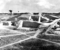
Excavated Sites Most important among the excavated sites is shalvan vihara,
which lies about the middle of the ridge in the vicinity of the present
day Bangladesh Academy for Rural Development (BARD) at Kotbari.
Excavations have exposed a large paharpur type Buddhist monastery and a
wealth of material objects datable from the 7th to 12th centuries AD. The
discoveries from the site include eight inscribed copperplates, about 400
gold and silver coins, many terracotta and baked clay seals and sealings,
a large number of sculptural specimens in stone, bronze and terracotta
found in situ or otherwise. The grand monastery together with its central
shrine was built by Shri Bhavadeva, the fourth ruler of the early deva
dynasty of devaparvata, sometime towards the end of the 7th or early 8th
century AD.
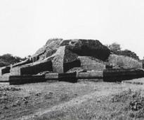
At kutila mura, the highest mound in the northeastern part of the
ridge near ananda vihara, were unearthed the most attractive monuments in
Mainamati The excavated monuments include three principal stupas and a
number of subsidiary chapels and chaitya-halls built around them, all of
which were enclosed by a massive boundary wall. Interesting and intricate
structural forms and decorative styles have been preserved at the site.
Excavations have not yet been completed here; the monastery in the
northern end and two grand stupas in two wings of the site remain to be
cleared yet. The excavated evidence suggests 7th century AD as the date of
the beginning of these monuments. The site continued to be occupied till
the 13th century AD as indicated by an Abbasid gold coin recovered from an
upper level of the site.
charpatra mura is an interesting small site, situated in the
northern part of the ridge in about the centre of the Cantonment area,
where was uncovered the remains of a small Hindu temple dated in the
Chandra period (10th-11th century AD). It is one of the earliest known
examples of Hindu temple architecture in Bangladesh. Four copperplates
were discovered in this monument and hence the name Charpatra (four
plates) Mura.
Largest among the Mainamati monuments is the Ananda Vihara. Situated in
the archaeologically rich Kotbari central area, it represents a huge
religious-cum-educational establishment of viharas, stupas and chapels all
around. Together with the largest water tank in the area, this Vihara
complex was built by Shri Anandadeva, the third ruler of the early Deva
dynasty, sometime at the end of the 7th or beginning of the 8th century
AD. Military contractors and brick hunters damaged this great
establishment with its central shrine beyond recognition in 1944-45.
Subsequently, the process of Cantonment building seriously affected the
site. Excavations carried out here for a few seasons in the late seventies
on a limited scale were incomplete in nature.
Next to Shalvan Vihara and Ananda Vihara, the
third most important and extensive monastic establishment in Mainamati is
the bhoja vihara, situated almost in the centre of the Kotbari area
adjacent to BARD. A huge water tank lies on its east. Excavations have
revealed the outlines of a square monastery with a large cruciform shrine
in the centre of its open courtyard, very similar to Shalvan Vihara and
Ananda Vihara.
Queen 'Maynamati's Palace Mound is the largest and highest mound in
the northern extremity of the ridge near to the village that still bears
the name of the queen, just east of Brahmanbaria road. The site is
traditionally associated with the legendary Chandra queen Mainamati,
mother of the last-known Chandra king, govindachandra. Excavations on a
limited scale have uncovered here parts of a massive defense wall round
different parts of the site, probably a citadel, and the corner of a
substantial structure, probably a palace, at the centre of the site. This
is probably the only site in Mainamati that has revealed structures of
secular nature. rupban mura, an important site, lies on a hillock
between modern BARD and BDR establishments in the Kotbari area on the
south of the Comilla-Kalirbazar road. Excavations have revealed here the
remains of a remarkable semi-cruciform shrine together with other
subsidiary structures. Deep diggings have revealed three main periods of
building and rebuilding, the earliest of which correspond to c.6th - 7th
centuries AD. Very little of the last period remains (10th - 11th
centuries AD) survive now in this very heavily disturbed site. Significant
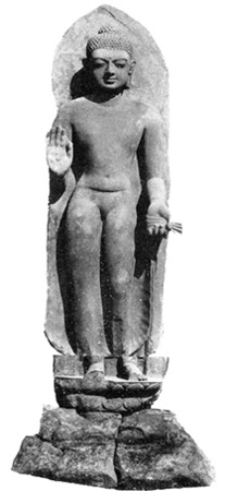
discoveries from the site include, besides the colossal stone Buddha, five
debased gold coins of Balabhatta, the Khadga ruler.
 Rupban
Mura an important archaeological site of mainamati lying on a hillock just
between the modern BARD and BDR establishments in the Kotbari area on the
south of the Comilla-Kalirbazar road. Excavations have revealed here the
remains of a remarkable semi-cruciform shrine of medium size (28.2m east -
west, 28m north - south), together with a number of subsidiary structures,
including an octagonal stupa and another one on a square base. A boundary
wall within the oblong stupa courtyard encloses all these. Its regular
entrance is on the east, facing the monastery entrance. Deep diggings have
revealed three main periods of building and repairs and rebuilding, the
earliest corresponding to c.6th-7th centuries AD. Very few remains of the
latest period (10th-11th century AD) survive now in this very heavily
disturbed site.
Rupban
Mura an important archaeological site of mainamati lying on a hillock just
between the modern BARD and BDR establishments in the Kotbari area on the
south of the Comilla-Kalirbazar road. Excavations have revealed here the
remains of a remarkable semi-cruciform shrine of medium size (28.2m east -
west, 28m north - south), together with a number of subsidiary structures,
including an octagonal stupa and another one on a square base. A boundary
wall within the oblong stupa courtyard encloses all these. Its regular
entrance is on the east, facing the monastery entrance. Deep diggings have
revealed three main periods of building and repairs and rebuilding, the
earliest corresponding to c.6th-7th centuries AD. Very few remains of the
latest period (10th-11th century AD) survive now in this very heavily
disturbed site.
The archaeological remains of itakhola mura lie in three terraces on the
hillock opposite to the Rupban Mura site across the Kotbari road. It
served for long as a quarry for old bricks and hence the name. Excavations
have revealed here a grand stupa complex with an attached monastery to its
north. Of the five cultural phases the earlier three lie buried underneath
the later remains. Mentionable antiquities from the site, besides the
stucco image, are three round pellets of solid gold (19 tolas) and a
copperplate, which is still to be deciphered.
Just near the Mainamati Bus Stop, north of the Dhaka-Chittagong highway,
lies mainamati mound 1a, where limited excavations have revealed six long
walls, straight and cross roads, gateways and other scant remains. The
non-religious and secular features of the remains suggest the existence of
a garrison barrack (?) here.
Unexcavated Sites Among the many unexcavated sites, mention may be made of
the Bairagir Mura, a medium sized high mound directly to the west of
Kutila Mura in the Cantonment. Brickbats, potsherds and fragments of stone
images found scattered on the surface strongly indicate its archaeological
importance. The site has been badly damaged by the construction of two
huge water tanks on its top for water supply to the Cantonment. A number
of objects were discovered during construction work; only two (dated in
the Chandra period) have found their place into the local museum - the
lower part of an inscribed colossal stone image standing on a lotus
throne, and the bronze life-size head of a Bodhisattva image.
The discovery of a colossal bronze bell, large dressed stone square blocks
(presumably pillar bases), one copperplate, and one stone plaque
inscriptions, and a number of bronze and terracotta sculptures clearly
indicate the importance of the Rupban Kanya Mura, situated in the middle
of the Kotbari area. But the site has now been levelled to accommodate the
parade ground and garages of the Cantonment.
The Kotbari Mound showed clear traces of a Shalvan Vihara type
monastery with a cruciform shrine in the centre. A grand mosque and its
attached graveyard have taken over the site.
Pakka Mura is an important unexcavated site (274m by 91m, 15m high)
on the western edge of the ridge, about a mile and a half southwest of the
Kotbari ruins. The importance of the site lies in its subsequent extension
to its lower base on the west, presumably after the river had dried out or
changed its course. A part of the silted up riverbed was turned into a
huge water reservoir called Tara Dighi, the deeper central part of which
has now been turned into two modern tanks. While constructing the larger
tank, about two acres in size, two interesting black stone images of Visnu,
one life-size and the other slightly smaller, showing mature Sena-Deva
characteristics, were found. Among other associated finds most significant
is a copperplate inscription of Dasharathadeva (13th century), son and
successor of Damodaradeva of the later Deva dynasty.
The extensive high mound on the western edge of the ridge, about 2.5 km to
the northwest of the southernmost site of Chandi Mura, locally known as
Rupban Mura, had visible structural remains in the shape of a circular
dome at the top of the mound. Removal of bricks by local inhabitants has
already caused destruction of the exposed structural remains. The site has
the potential of yielding important remains.
At the extreme southern end of the ridge, about 1.6 km to the northwest of
Lalmai railway station, is a prominent mound (457m by 183m, 18m high),
locally called Chandi Mura. The site derives its name from the twin
temples of Chandi built on the summit of the mound, some 250 years back by
a Maharaja of Tripura. The archaeological character of the site is
undisturbed; the mound probably contains the remains of a large temple.
The top of the mound was badly damaged, first by the construction of the
Chandi temples, and later by modern constructions undertaken by people
associated with the temples. However, the archaeological remains at the
lower levels may still be intact.
Among other unexcavated sites, mention may be made of Mainamati Mound 2,
Abbas Ali Mura, Station Commander's Residence, Hatigara Mound, Ujirpur
Mound, Ghila Mura and Balaghazir Mura. All these sites have yielded
evidence of remains of archaeological importance. Most of these sites are
now in bad shape due to willful or unwillful negligence of the people
occupying the mounds or their neighbourhood.
Antiquities The Mainamati excavations have yielded an exceptionally rich
harvest of valuable antiquities including twelve copperplate grants and
shorter image-inscriptions, over 400 gold and silver coins, innumerable
terracotta and clay seals and sealings, some Neolithic stone axes and
chisels, a large collection of stone, bronze, stucco and terracotta
sculptures, stone and terracotta beads, gold, silver and bronze ornaments,
decorative terracotta and architectural pieces, metal and earthenware
pots, pans, vases and utensils, oil lamps and a variety of other objects
of everyday use. The majority of these objects comes from Shalvan Vihara,
the most systematically excavated site. Together, they contribute
significantly to our knowledge of ancient Vanga-Samatata, covering a
period of about seven hundred years from the 6th to 13th centuries AD.
No fewer than twelve copperplate grants have been recovered from the
excavations, which throw most welcome light on the history, culture,
society, and economy of southeastern Bengal. Among the many short
dedicatory or votive inscriptions the few bearing the original name of
Shalvan Vihara and its royal builder are very significant.
Mentionable among the numismatic finds are a few Gupta and post-Gupta
imitation gold coins, a rare silver coin of shashanka, about a dozen gold
coins of the Khadga ruler Balabhatta, few Arakanese and hundreds of
harikela and 'Akara' dynasty coins, and one gold, and a few silver coins
of Abbasid Caliphs.
The sculptural finds in stone, bronze, stucco and terracotta represent the
largest single group of antiquities other than pottery. Stone sculptures
are rare, but include a fine stucco sculpture though damaged, it is an
interesting specimen. The bronzes primarily represent religious art and
show a perplexing variety of iconographic types, revealing the gradual
transformation of the popular faith Mahayana to Tantric and ultimately to
polytheistic forms in which Buddhism became inextricably mixed with Hindu
and aboriginal elements. The sculptured terracotta plaques are the most
numerous, attractive and representative of local folk art. They are
remarkable both for their crude but vigorous style and local
characteristics.
About a dozen ground and polished narrow-butted hand-axes and chisels,
mainly of fossil wood, have been recovered from the excavations. Recent
explorations have uncovered a few Neolithic settlements in the southern
part of the Mainamati ridge. The collected specimens must have originally
come from there. They show clear affinity with the Neolithic industries of
West Bengal, Bihar and Orissa.
Mainamati excavations have, thus, thrown a flood of light on almost every
aspect of the life and culture of the southeastern part of Bengal. It has
supplied detailed information regarding the social, political and economic
condition of the region and has led to the discovery of the remarkable
early Deva dynasty and of Balabhatta, the founder of Devaparvata. It has
settled a number of historical and geographical questions, for instance,
concerning the extent and bounds of Samatata, the location of Devaparvata,
Pattikera and Lalambi-vana, and the situation of Harikela. More important,
with the studies and analysis of terracotta and the classification and
sequence dating of the pottery types and other common objects, Mainamati
has now provided set a workable basis for further investigations and
research in the field. Mainamati finds have no doubt broadened the horizon
of our understanding of our past.
The primary significance of this collection lies in the fact that it
represents the only available authentic and contemporary stratified
materials from southeast Bengal that provide for the first time a
dependable archaeological basis for the reconstruction of the history and
civilisation of this region of Bengal. (M Harunur Rashid]